


 Comprehensive weather insights help safeguard your operations and drive confident decisions to make everyday mining operations as safe and efficient as possible.
 Learn how to optimize operations with credible weather and environmental intelligence. From aviation safety to environmental compliance, our comprehensive suite of solutions delivers real-time insights, advanced forecasting, and precise monitoring capabilities.
 Daily Video Updates
DTN expert meteorologists are providing daily updates to keep restorations crews, first responders and others safe during recovery efforts . Watch the videos to see developing weather events.
Learn More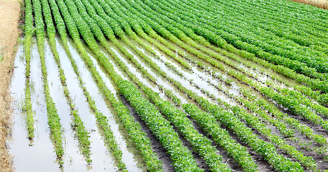
Agriculture Impact
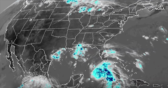
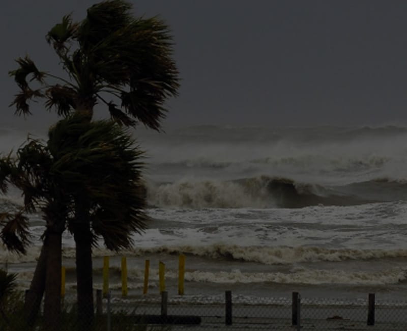
Hurricane Ida made landfall near Port Fourchon, Louisiana at 11:55 a.m. on Aug. 29, 2021 as a strong Category 4 hurricane with maximum sustained wind speeds at landfall of 150 mph, but it is the rainfall that will be the focus for agriculture. Rainfall amounts of 8 to 14 inches are likely across southern Louisiana near landfall, with gradually decreasing amounts as the system moves farther inland. Still, the southern half of the Delta is likely to experience rainfall of 3 to 6 inches and possibly higher. Open cotton bolls and desiccating soybeans will run the risk of flood damage. How far north the damage goes depends on when the system makes a turn to the east. Cotton in Alabama may endure some flood risk from storm surge that is close to the coast, but farther inland and through Georgia, the current track brings minimal impacts with some risk of moderate rain as the system passes by to the west and north early next week. Through the Carolinas and Virginia, however, flooding risks increase and could be significant for cotton and other crops in the region.
Read more.
Utilities Impact
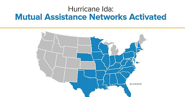
Efforts have shifted from preparation to restoration in the affected areas. According to the Edison Electric Institute at least 33 states and more than 25,000 workers have mobilized to support power restoration efforts.
To help keep crews be weather aware and forewarned of developing weather events we are providing our specialized daily mutual assistance weather briefings at no cost. The daily updates are available on our YouTube channel here until September 10. Please share with the appropriate people so they can track and be prepared for developing weather conditions in the affected areas.
We continue to monitor and consult with our utility customers in the affected areas, as well as along the East Coast.
Oil and Gas Impact
As of September 8, 76.9%, or 1.39 million bpd, of offshore crude oil production and 1.72 Bcf/d, or 77.25%, of offshore natural gas production is still shut-in as a result of Hurricane Ida. A cumulative total of 20.6 million bbl of crude oil production and 24.5 Bcf of natural gas production has now been shut-in because of the storm.
Ongoing inspections of Louisiana and offshore oil infrastructure in the days following hurricane Ida revealed damage to Port Fourchon oil infrastructure as well as Shell’s WD-143 transfer station. The Mars corridor, including the Mars, Olympus and Ursa platforms are serviced by the WD-143 transfer station for ultimate delivery to Chevron’s Fourchon terminal and LOOP’s Clovelly terminal. A prolonged outage of the transfer station could prevent these crude production platforms from returning to normal operations despite not sustaining serious damage. According to Louisiana Department of Natural Resource data, the Mars pipeline carried a monthly average of 376,000 bpd of crude to LOOP facilities in the January – July 2021 period.
Of the roughly 2.3 million bpd of shut-in refining capacity as a result of the storm, 1 million bpd of capacity remains completely offline. About 1.3 million bpd of capacity at four refineries in the region have initiated the restart process but are unlikely to return to full throughput this week.
Flooding Impact
The Automated Surface Observing Systems measured phenomenal short-duration rainfall amounts as the remnants of Hurricane Ida passed by on September 1. New York City Central Park received more than 5 inches and Newark Liberty Airport measured nearly seven inches of rain in three hours. A deeper evaluation of the unconstrainted amounts would likely reveal higher hourly totals:
Using NOAA Atlas 14 to put these rainfall amounts into a statistical perspective indicates the 2-hour value at Newark correlates to about a 1 in 1000 chance in any given year. Meanwhile, the 3-hour total of 6.42″ exceeds the 1 in 1000 chance in any given year by about 10%!
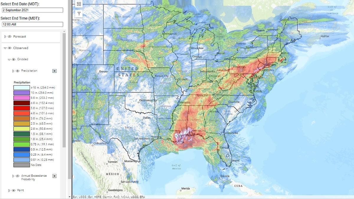
The heaviest rain from Ida fell at both coasts – the Mississippi/Alabama Gulf Coast and along the mid-Atlantic coast, particularly in/near New Jersey. The map below from the DTN MetStormLive quantitative precipitation estimation model shows the 7-day precipitation ending September 2nd. The swath of heavy rain from Ida is clearly visible with several areas receiving over 10” (white areas) of rainfall from the Hurricane.
In the News
U.S. Gulf Coast residents flee ‘extremely dangerous’ Hurricane Ida
Ida continues to strengthen, along with concern about explosive development shortly before landfall. Chief Meteorologist Jim Foerster provides more detail.
Learn More
U.S. offshore oil workers flee as storm nears Gulf of Mexico
Even though the tropical storm is still developing, offshore operators are beginning to evacuate. Chief meteorologist Jim Foerster explains why the storm is a threat.
Learn More
Hurricane Ida’s path poses ‘worst-case scenario’ threat to Gulf energy assets, analyst says
Companies with offshore and onshore energy assets are bracing for the arrival of Hurricane Ida, whose projected path poses the biggest tropical threat so far this season for the oil and gas industry.
Learn MoreFollow our storm coverage on social media or contact us for media inquiries.

If changing weather conditions during the Atlantic hurricane season impacts your business operations, we can help.
Get in Touch