


 Comprehensive weather insights help safeguard your operations and drive confident decisions to make everyday mining operations as safe and efficient as possible.
 Learn how to optimize operations with credible weather and environmental intelligence. From aviation safety to environmental compliance, our comprehensive suite of solutions delivers real-time insights, advanced forecasting, and precise monitoring capabilities.
 You’re observing the freshly fallen snow at your location. While the scene can be breathtaking, how does that blanket of snow affect temperatures afterward? In most cases, sunlight reaching the Earth’s surface causes temperatures to increase throughout the day. When snow covers the ground, the incoming radiation is reflected into space. The amount of solar
Category: Weather
Have You Heard of a Frost Quake Before?
The polar plunge is continuing across portions of the country, producing dangerously low wind chills. The cold temperatures are also causing a phenomenon known as frost quakes. People in portions of the Midwest have recently been observing loud noises described as banging sounds or loud booms. If you have heard this, it may be a
Winter Roadmap: A 7-Step Checklist For Safer, Smarter Road Maintenance
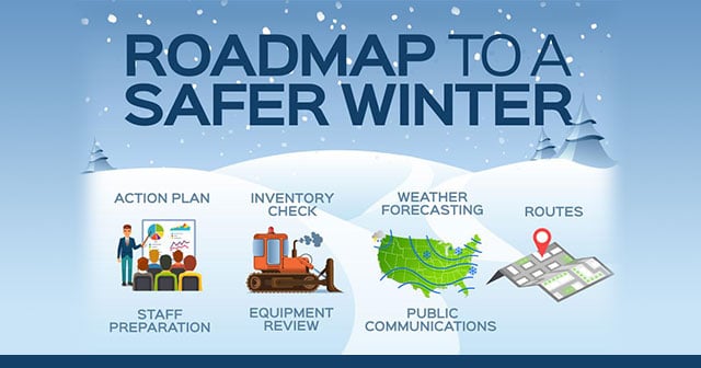
With 75% of the US population suffering below-freezing temperatures this week, and no less than 3,480 domestic flights being cancelled, road maintenance teams might feel like they’re playing whack-a-mole with Mother Nature as they rush to salt or brine roads on routes that have been worst impacted by the extreme weather.
Blow Ice: Navigating The Hazards

It’s late February and the heaviest snow storm of the season has just dumped a foot of snow in your area. Road maintenance crews have cleared much of the snow from public roads and your favorite TV meteorologist is forecasting abundant sunshine, albeit amidst frigid temperatures and brisk winds, for the next few days.
Weather Leads as Aviation Disrupter – Mitigation is Key
It’s no secret that bad weather can play havoc on the aviation industry. According to a 2016 study in Physical Geography, the weather was a cause or contributing factor in 35% of fatal general aviation accidents. It seems that we’re even more aware of weather’s impact on travel at this time of year when winter
Here’s What Determines the Type of Winter Precipitation That Falls
All precipitation develops in the same way, but in winter there can be quite a variety of types. Freezing rain, sleet, snow, are all possible when it gets cold outside. Freezing Rain Freezing rain forms when the air higher in the atmosphere is above freezing while the ground temp is below 32°F. Warmer air will cause falling snow to
Rime Ice or Hoar Frost? There is a Difference!
Have you ever stepped outside and all the trees and surfaces are covered with frost? If you look close enough, it sometimes resembles sharp spikes, and other times it may appear to be flat crystals. One of these is hoar frost, the other is rime ice. Many confuse the two, so let’s dig a little
5 Snow and Ice Oddities You’ve Likely Never Heard Of
Winter is on the way, and many areas have already experienced their first snowfall, along with frigid temperatures. It may be cold, and daylight is limited, but some rare phenomena only occur in these conditions. When you combine snow, ice, and freezing temperatures, many unique things can happen. Snow Rollers When you want to make
What Roles Will AI And Machine Learning Have In Feeding The World?
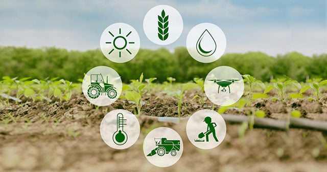
For thousands of years, the survival of farmers’ crops — and finances — have been inextricably linked to the weather.
The Role of Weather—and Weather Forecasting—in Agriculture
Most people know that the weather has a significant impact on the agriculture industry. Indeed, crops need the basics of moisture, warmth, and sun to thrive. But what’s less obvious is how the details of weather information can drive a grower’s business decisions, helping them to plan efficiently, minimize costs and maximize yields—and profits—as a