What’s Up With The 2022 Hurricane Season?

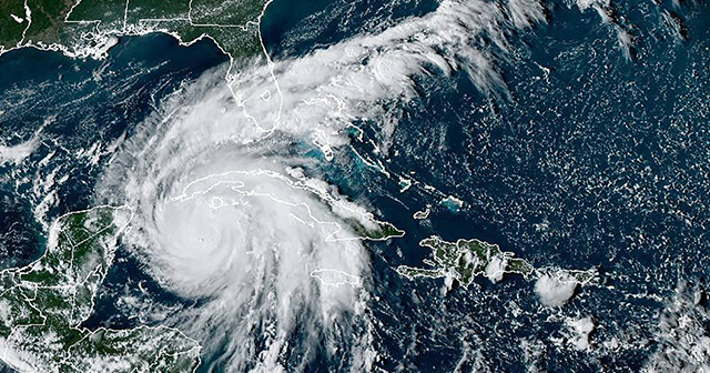
In August, everyone was wondering if this year’s tropical season was going to be unusually quiet despite long range forecasts predicting another active season. In fact, there hadn’t been a single named storm since early July, which hadn’t happened in more than 25 years. Yet, just hours into September, Hurricane Danielle developed and was quickly followed by Hurricane Earl. Then Hurricane Fiona, a category 4 hurricane, battered the Dominican Republic and Canada. Now, in the last week of September, Florida, and states along the eastern coast, are facing major Hurricane Ian, which could leave massive flooding in addition to high winds.
This season’s storm activity has many people wondering just what goes into a hurricane season forecast and what has impacted this year’s tropical activity. DTN Chief Meteorologist Jim Foerster, one of just 239 Certified Consulting Meteorologists in the world, recently addressed this topic for Forbes.com.
How Hurricane Season Forecasts are Made
Most hurricane-season forecasts start by looking at the primary environmental factors, like water temperatures and upper-level winds, that influence tropical activity and just how favorable those factors are for tropical storm development. At a high level, hurricane season forecasts are relatively straightforward to forecast. The job becomes increasingly more complicated when attempting to forecast conditions impacting tropical development several months in advance.
While there are many factors that influence tropical activity, such as atmospheric moisture, the most important one to consider is the ocean temperature. Tropical convection, which powers hurricanes, is fueled by warm ocean water. To fuel tropical storms at lower latitudes, ocean water temperatures need to be 80F or higher. Another important factor is where those warmer water temperatures are found as well as the overall extent of the warm water.
Wind speeds at different heights are another environmental factor that influences tropical storm development. Ideal tropical development requires calmer and more uniform winds, but when compared to ocean temperatures, which vary slowly and are generally easier to predict, wind patterns change frequently and are harder to predict at long-lead times.
Why Was Early 2022 Hurricane Season Quiet?
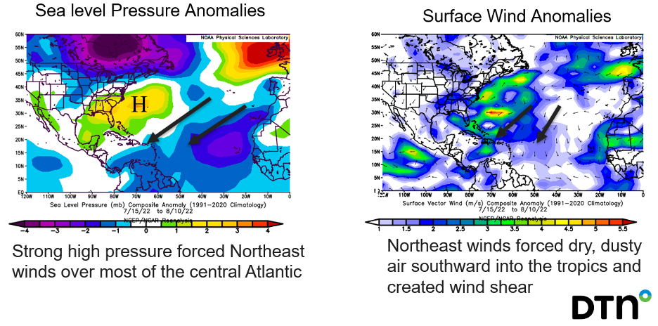
While it’s often assumed that air masses over the ocean will be moist, it’s not always the case, particularly above the lowest atmospheric levels. This summer’s hurricane activity was strongly influenced by dry air, and to a lesser extent wind shear, resulting in limited storm development. However, since the first day of September, the flow of dry air and the wind shear have lessened significantly, allowing for Atlantic storms to begin developing resulting in a more active second half of the hurricane season.
Early 2022 Hurricane Anomalies

What Changed in September?
September is usually the most active month of the hurricane season since ocean temperatures reach their annual peak around mid-month and wind shear typically is at a minimum. The warmer water temperatures and lower wind shear levels helped conditions become more favorable for tropical development in September, but a couple of additional factors also played a role.
The persistent plume of dry, dusty air originating from the Sahara routinely inhibits tropical storm formation early in most hurricane seasons, but this year they persisted into August. Another change this month was the development of widespread rising motion in the atmosphere across the Atlantic basin. Large atmospheric waves typically bring alternating periods of enhanced rising or sinking motion to different tropical basins. When these waves enhance rising motion in the atmosphere during periods of low wind shear, reduced dry air, and warm water temperatures, the result is usually a spike in tropical activity. All those factors combined to produce this recent period of heightened tropical activity.
We are still more than a month away from the end of the official hurricane season, but as we have experienced, hurricanes develop on their own timelines. And, as we have also experienced, it only takes one major hurricane to disrupt infrastructures, business continuity and public health and safety for many years. Constantly monitoring the tropical storm outlook, tracking evolving storms in real time and communicating the risks are key to ensuring the impact is as minimal as possible.
DTN Insights Mean Confident Decisions
With this insight into how the tropical storm seasonal outlook is developed, there is real value for governments and businesses to understand the environmental conditions involved in hurricane forecasting. This knowledge can help inform decision making to protect people and assets from potential risk. Using our Severe & Tropical Weather Suite can help forecast, monitor and assess risks, provide alerts and advice leading up to and during impactful weather events, and offer post-storm analysis. Working with a skilled risk communicator can be invaluable in taking hurricane preparations and response to the next level.


 Comprehensive weather insights help safeguard your operations and drive confident decisions to make everyday mining operations as safe and efficient as possible.
 Learn how to optimize operations with credible weather and environmental intelligence. From aviation safety to environmental compliance, our comprehensive suite of solutions delivers real-time insights, advanced forecasting, and precise monitoring capabilities.

