Hurricane Florence

We at MetStat, now DTN, are watching with bated breath as Hurricane Florence tracks westward toward the Carolinas. At this time, the most widespread impacts will be flooding from torrential rain, though areas near the coastline will experience intense and destructive winds as well.
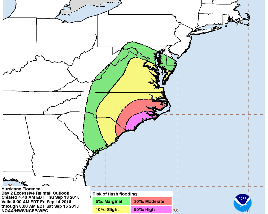
National Hurricane Center Risk of Flash Flooding for Hurricane Florence
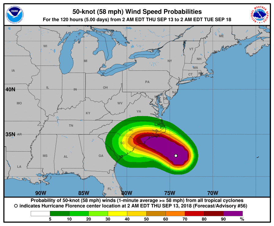
National Hurricane Center 50-knot Wind Speed Probabilities for Hurricane Florence
The forecast precipitation intensities are showing persisting extreme rains according to the current average recurrence interval of the 24-hour WRF QPF ending at 5am EDT on the 15th and the subsequent 24-hours ending at 5am EDT on the 16th. Over 1000-year ARI values are expected at the 24-hour duration for both of these forecast periods.
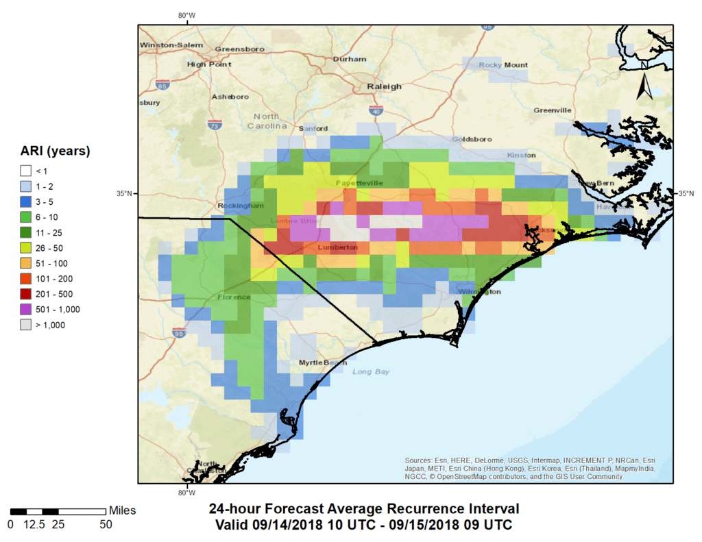
Average Recurrence Interval of WRF 24-hour QPF Ending Sept. 15 5am EDT
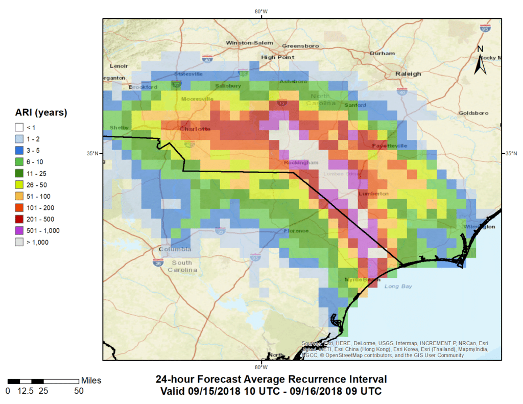
Average Recurrence Interval of WRF 24-hour QPF Ending Sept. 16 5am EDT
We will be keeping a watchful eye on Florence as it makes landfall and will update our post as new data come in. For those in track of this hurricane, please stay safe and remember turn around, don’t drown when encountering flooded roads.
——————————————UPDATE 18 September 2018——————————————
Hurricane Florence was well established long before it made landfall on Friday September 14th. It had gone from tropical storm to major hurricane in the Atlantic only to encounter significant shear that weakened the system back down to tropical storm strength. As it continued west-northwestward the vertical wind shear weakened and the system moved over warmer waters, all of which allowing the storm to build once again to major hurricane strength. As it approached the coastline, Florence began to interact with downstream ridging over the Eastern US. This slowed the system down and caused upwelling and therefore cooler ocean temperatures, which also contributed to its weakening prior to its arrival. Florence made landfall on Friday morning as a Category 1 storm, and many of the factors that contributed to its prior weakening were also responsible for the system stalling over the Carolinas in the days that followed.
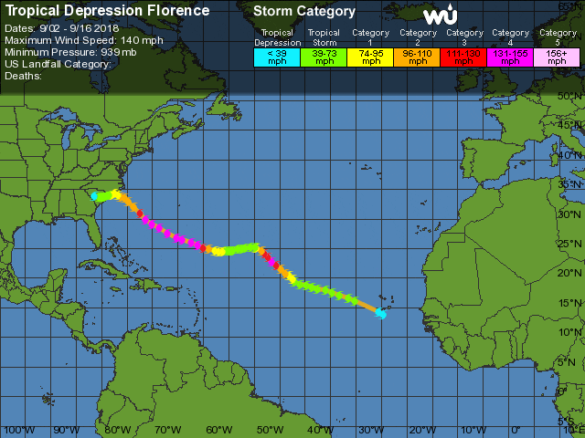
Tropical Depression Florence Track Map (source: Wunderground)
Over the weekend, DTN continued to monitor the extreme precipitation from Florence as it made landfall, stalled over the Carolinas, and finally moved northward. We provided emergency managers in South Carolina with forecast ARI maps as well as continual updates of observed ARI data as it became available. The observed data is based on MetStormLive gauge adjusted QPE and frequency estimates from NOAA Atlas 14 Vol 2. These estimates are preliminary as of the update of this post and will remain the case until a full manual MetStorm analysis is performed and gauge values are verified.
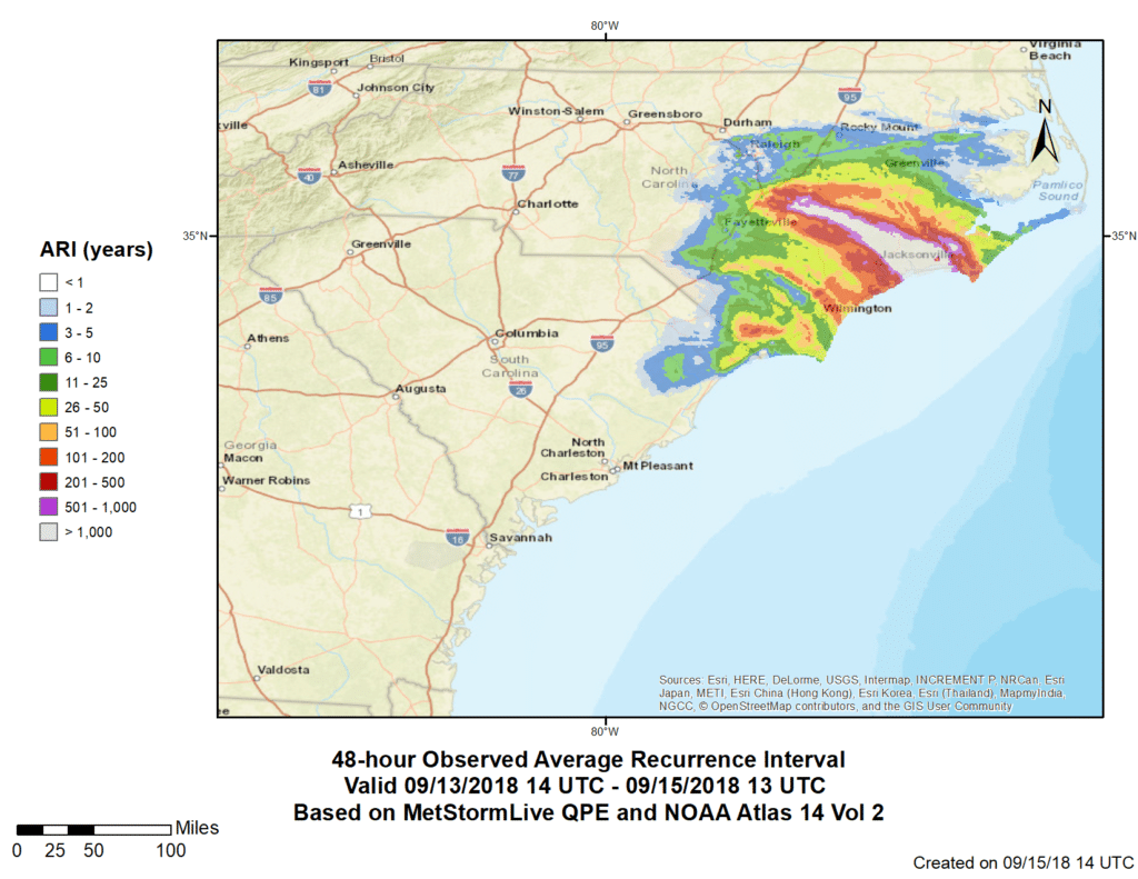
Preliminary 48-hour ARI valid Thursday September 13th at 10am EDT through Saturday September 15th at 9am EDT.
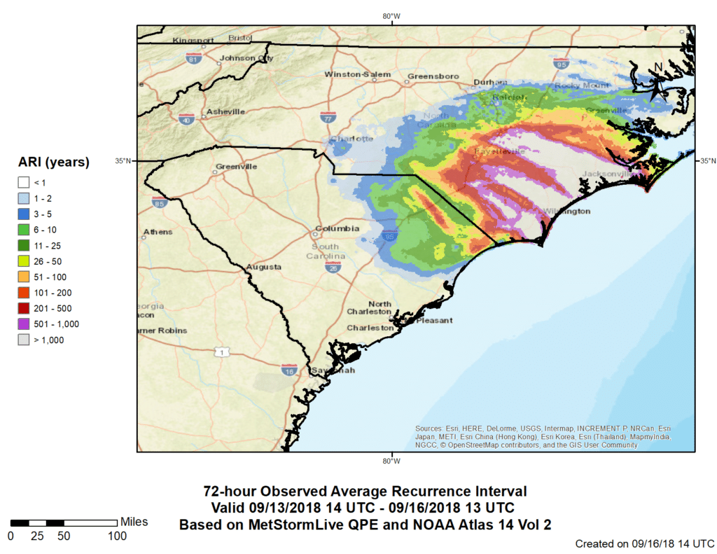
Preliminary 72-hour ARI valid Thursday September 13th at 10am EDT through Sunday September 16th at 9am EDT.
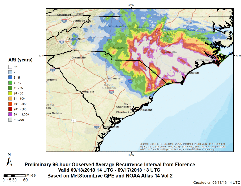
Preliminary 96-hour ARI valid Thursday September 13th at 10am EDT through Monday September 17th at 9am EDT.
The rarity of this storm from a multiple duration perspective shows just how persistent the intensity of precipitation rates were over the weekend. Now that the remnants of Florence have moved northward, the Carolinas will have a chance to start to recover from this incredible event.


 Comprehensive weather insights help safeguard your operations and drive confident decisions to make everyday mining operations as safe and efficient as possible.
 Learn how to optimize operations with credible weather and environmental intelligence. From aviation safety to environmental compliance, our comprehensive suite of solutions delivers real-time insights, advanced forecasting, and precise monitoring capabilities.
